India’s National Board for Wildlife Approves Key Road Projects to Strengthen Military Infrastructure Along the LAC
(Source: Indian Express; Section: Cover Page; Page: 01)
| Topic: GS3 – Internal Security |
| Context: |
|
Analysis of News:

Strategic Importance of Road Development
- The recent approval by the National Board for Wildlife (NBWL) for five key road stretches, particularly through the Karakoram Wildlife Sanctuary along the Line of Actual Control (LAC), highlights India’s continued efforts to bolster military infrastructure in Ladakh.
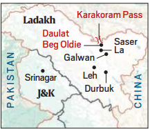
- These road projects are crucial for providing alternative and faster access to Daulat Beg Oldie (DBO), the country’s northernmost military outpost and home to its highest airstrip.
- This is part of India’s broader strategy to enhance operational readiness along the sensitive border with China.
Road Stretches and Their Role
- The approved stretches include a road linking Chushul-Lukung to Thakung post and another between Durbuk-Shyok-Daulat Beg Oldie (DS-DBO) and Saser-Brangsa-Gapshan.
- The construction of the DS-DBO to Saser-Brangsa road, which will be built at an altitude of 17,000 feet, is particularly significant. These new routes are strategically designed to improve troop and resource mobility, especially in times of hostilities.
- The DS-DBO route, already close to Chinese-held territory, provides crucial surveillance and response capabilities.
- The new roads will allow India to respond quickly to any developments along the LAC, especially in light of ongoing tensions following the 2020 Galwan Valley clashes.
Enhancing Tactical and Operational Capabilities
- The Ministry of Defence emphasized the importance of these roads for maintaining tactical dominance in critical areas. Regular patrolling and quick reaction teams stationed along these routes will ensure effective border management.
- During hostilities or border management operations, quick movement of troops and logistics becomes essential. The DS-DBO to SBGG link road plays a key role in this, allowing faster and more efficient deployment in the Sub-Sector North, which is highly sensitive to Chinese transgressions.
Leh-Chalunka Road and Local Connectivity
- Another key stretch, the Leh-Chalunka road, serves a dual purpose of connecting the Indus and Shyok valleys and ensuring maintenance of both military and civilian logistics in the Nubra valley.
- It is the only motorized road over the Ladakh range and plays a vital role in sustaining troop presence in this challenging terrain.
Wildlife and Environmental Considerations
- While these projects are vital for national security, they traverse ecologically sensitive areas such as the Karakoram Wildlife Sanctuary and Changthang cold desert sanctuary.
- The NBWL has cleared the projects with conditions, including the implementation of animal passage plans to minimize impact on local wildlife.
- Additionally, the Defence Ministry is required to obtain the necessary forestland diversion permissions, if applicable, ensuring that ecological concerns are addressed alongside defense imperatives.
Conclusion
- These new road projects mark a significant step in India’s efforts to strengthen its defense posture along the LAC.
- By improving connectivity to critical military outposts and ensuring rapid deployment capabilities, these infrastructure developments are key to maintaining operational readiness in the face of potential border conflicts with China.
- At the same time, balancing environmental concerns remains a challenge as these projects move forward.
| India and China Border Dispute |

|
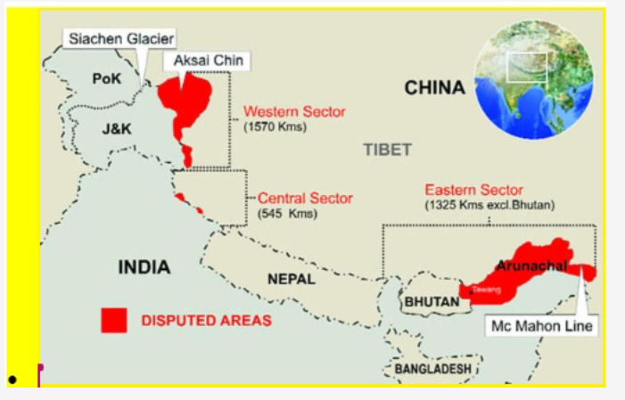
| PYQ: Siachen Glacier is situated to the (2020)
(a) East of Aksai Chin (b) East of Leh (c) North of Gilgit (d) North of Nubra Valley Ans: (d) |
| Practice Question: Critically analyze the implications of the National Board for Wildlife’s clearance of road projects in the Karakoram Wildlife Sanctuary for India’s national security and wildlife conservation. What measures should be taken to balance military infrastructure development with environmental protection? (150 words/10 m) |
