25 Jan 2024 : Daily Answer Writing
Q1) With the help of an annotated diagram, discuss the various landforms of karst region. Why is ‘underground scenery’ very well developed in karst region?
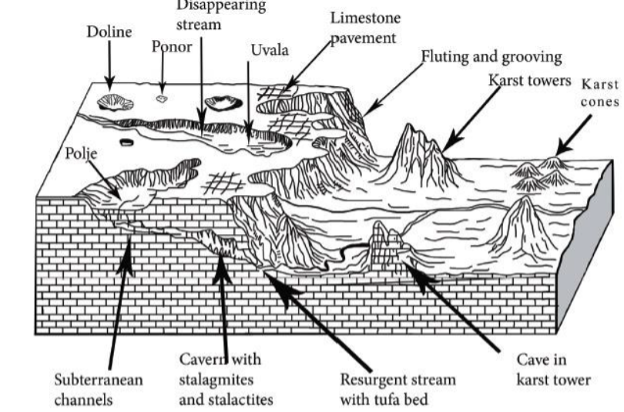
Karst is a topography formed by the dissolution of soluble rocks such as limestone, dolomite, and gypsum. This process creates a unique landscape of distinctive landforms, as shown in the annotated diagram below:
- Sinkholes: Sinkholes or dolines are circular depressions in the ground formed when the roof of an underground cavern collapses.
- Caves: Caves are underground chambers and passages formed by the dissolution of limestone by acidic groundwater. They are often decorated with stalactites, stalagmites, and other speleothems formed by the precipitation of dissolved minerals.
- Ponors, Springs, and Resurgence: Ponor is a portal through which surface water flows underground. Springs are natural outlets where groundwater emerges from the subsurface. Resurgences are where underground rivers or subterranean streams re-emerge at the surface.
- Tower/ Karst Cones: These are isolated towers or pinnacles of limestone or dolomite that rise above the surrounding landscape. They are formed by the erosion of soluble rocks, leaving behind more resistant rock formations.
- Polje: A polje is a large, flat-bottomed depression in the landscape, often formed by the collapse of underground caverns or the dissolution of soluble rock.
- Uvala: Uvalas are shallow, enclosed basins in karst regions formed by the merging of several dolines.
The ‘underground scenery’ is very well developed in karst regions due to the following reasons:
- Unique geological characteristics: The karst topography is formed in regions where the rock below the surface of the Earth can be easily dissolved by groundwater. The soluble rock formations, such as limestone, gypsum, or carbonate rocks dissolve in the presence of acidic water. For example, Gaping Ghyll in Yorkshire.
- Underground drainage systems: The soluble rocks allow for the easy movement of water through the rocks. The continuous flow of water through the underground passages develops extensive cave systems.
- Long passage of time: Development of karst topography can take hundreds to thousands of years, including periods of glaciation, sea level change etc. Extensive natural ecosystems develop in this period in these regions. E.g., the Great Blue Hole in Belize, which is a UNESCO World heritage site.
- Anthropogenic factors: Sometimes, man-made reasons such as extensive mining, divergence of surface water, or climate change factors such as increased rainfall and storm events cause subsidence of underlying limestone and similar rocks. E.g., the mining of coal, zinc, lead, and iron ore deposits in karst areas of China is associated with the formation of sinkholes.
Overall, the unique geological and hydrological features of the karst region make it an ideal environment for the development of underground scenery, including extensive cave systems, unique rock formations, and diverse ecosystems.
Upload Answer here


