Human Settlements- UPSC Notes
Human Settlements
The human population is highly concentrated in the world. About 90% of the world’s population lives in just 10% of the area. 10 most populous countries contribute 60% to the world’s population. What affects the distribution of population around the earth? Let’s find out.
The pattern of population distribution:
About 90% of the world’s population lives on 10% of the land. The distribution ratio for Asia, Africa, Europe, and North/South America is 4:1:1:1.
However, by the end of the century, it is expected to grow in the proportion of 5:3:1:1, after which the population growth would stabilise all over the world.
The density of Population: The number of people per square kilometre is 51 worldwide, with the highest density in South Asia, followed by East and Southeast Asia.
Distribution of Population
- Geographical Factors Availability of water: for drinking, cattle, crops, industries and navigation; River valleys densely populated.
- Landforms: People prefer to live on plains: favourable for the production of crops and to build roads and industries; Ganga plains are densely populated.
- Climate: Moderate climate favourable. Areas with heavy rainfall or extreme and harsh climates have low populations.
- Soils: Fertile soils are important for agriculture.
- Economic factors Minerals: Areas with mineral resources attract industries and mining activities, and generate employment and economic activities. For example, Katanga Zambia copper belt in Africa.
- Urbanisation: Better employment opportunities, educational and medical facilities, better means of transport and communication in cities. They grow in size to become megacities.
- Industrialisation: Industrial belts provide job opportunities and attract a large number of people, which produces other economic activities.
- Social and Cultural Factors: Places of religious or cultural significance.
- Administrative: These cities exist at Strategic locations.
- Capital cities – National Capital, State Capitals
- Defence – Cantonments, Military towns etc.
- Division headquarters, District headquarters etc.
Rural Settlements:
Villagisation – Human settlements generally tend to cluster due to various factors such as security, and availability of resources. This process is known as villagization. These are termed as rural settlements as these are most closely and directly related to land, and are dominated by primary activities.
Resources and features
What influences village settlement patterns?
- Water Supply: rural settlements are usually located near water bodies such as rivers, lakes and springs where water can be easily obtained. Sometimes need for water drives people to otherwise disadvantaged sites. For example, an Island site surrounded by swamps or low-lying areas.
- Land: There is a tendency to settle near fertile Plains. For example, European villages developed near rolling countries avoiding swampy, low-lying land, while South East Asia chose to live near low-lying river valleys.
- Upland: Higher areas are not prone to flooding. Often Terraces and levees, which are dry points, are inhabited.
- Building materials: settlements near the source of wood and stone are an added advantage; For example:
- In loess areas of China, cave dwellings were important.
- African Savanna’s building materials were mud bricks.
- Eskimos, in polar regions, use ice blocks to construct igloos.
- Defence: During times of political instability, war, and hostility of neighbouring groups villages were built on defensive hills and islands.
- Nigeria: inselbergs (High stones) formed good defensive sites.
- India: most forts are located in higher grounds.
- Planned settlements: Not spontaneously chosen by the villagers themselves: constructed by governments by providing shelter, water and other infrastructures on acquired lands.
- Ethiopia: scheme of villagisation.
- Canal colonies in the Indira Gandhi Canal
Sometimes some of the rural settlements grow up to become economic growth centres. These larger settlements are called Towns and Cities.
Difference between rural and urban settlements
| Rural settlements | Urban settlements | |
| Economic Activity | Rural settlements derive their life support or basic economic needs from land-based primary economic activities. | Urban settlements depend on the processing of raw materials and manufacturing of finished goods on the one hand and a variety of services on the other. |
| Social relationship, attitude and outlook. | Rural people are less mobile and therefore, social relations among them are intimate. | In Urban areas, the way of life is complex and fast, and social relations are formal. |
A functional relationship between cities and villages
Cities act as nodes of economic growth and provide goods and services not only to urban dwellers but also to the people of the rural settlements in their hinterlands in return for food and raw materials.
This functional relationship between the urban and rural settlements takes place through transport and communication networks.
Types of Rural Settlement:
- Clustered Settlements: Compact or closely built houses, here general living areas separate and distinct from farms. Intervening streets present, some recognisable patterns. Such settlements develop for security or defence reasons, such as in Bundelkhand, Nagaland, and Rajasthan (due to water).
- Semi-Clustered: Result from the tendency of clustering in an area. Or one society chooses or is forced to live a little away from the main cluster.
- Hamleted Settlements: Fragmented into several units physically separated from each other bearing a common name.
- Locally called panna, para, palli, nagla, dhani, etc.
- Segmentation of large villages is often motivated by social and ethnic factors.
- Such settlements are very common in the middle and lower Ganga plains, Chhattisgarh and lower valleys of the Himalayas.
- Dispersed or isolated settlements: in India appear in the form of isolated huts or hamlets of a few huts in remote jungles, or on small hills with farms or pastures on the slopes. Extreme dispersion of settlement is often caused by the extremely fragmented nature of the terrain and land resource base of habitable areas. Many areas of Meghalaya, Uttaranchal, Himachal Pradesh and Kerala have this type of settlement.
Rural Settlement Patterns:

- Based on setting: plain villages, Plateau villages, coastal villages, forest villages and desert villages.
- Based on functions: Farming villages, fishermen’s villages, lumberjack villages, pastoral villages etc.
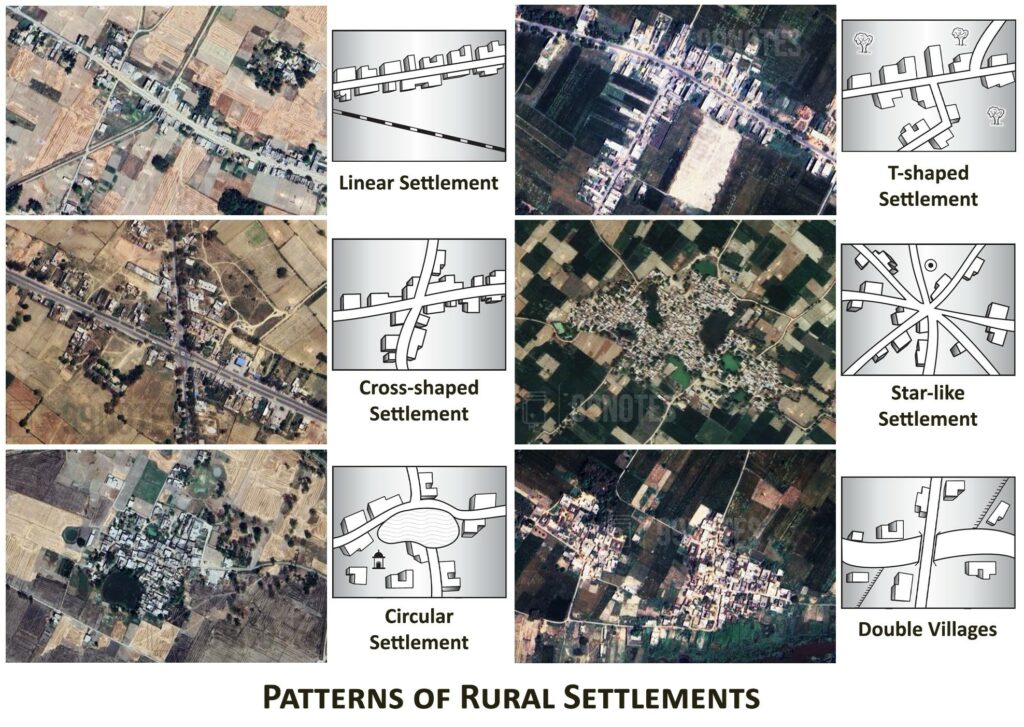
- Based on forms or shapes of settlement: Geometrical form:
- Linear: along a road, river or canal edge, a valley or along a levee.
- Rectangular: Found in plain areas or wide montane valleys. Roads are rectangular and cut at right angles. We see such settlements in planned villages or those villages that are developed, for example in Haryana.
- Circular: developed around lakes, and tanks and sometimes planned in such a manner that the central part remains open and is used for keeping the animal protected from wild animals.
- Star: These are settlements formed due to the convergence of several roads at one location.
- T-shaped, Y-shaped, cross-shaped village or cruciform-shaped: develop at tri-junctions of roads. Develop at crossroads and houses extend in all directions.
- Double villages: When settlements extend on both sides of a river where there is a bridge or a ferry.

The problem of Rural Settlements:
In developed countries like India, large in numbers but poorly equipped with infrastructure. They represent a great challenge and opportunity for planners.
- The supply of water is not adequate in rural areas – have to walk long distances and water-borne diseases like Cholera and jaundice tend to be common problems; In South Asia, Drought and flood are common; and crop failure due to the absence of irrigation.
- The general absence of toilets and garbage disposal facilities – health problems;
- The design and use of building materials of houses vary from one ecological region to another. Houses made of thatch, mud and wood remain susceptible to damage during heavy rains and floods and require proper maintenance -most of them deficient in ventilation.
- The design of the house includes an animal shed along with a fodder store within it. It Protects food from wild animals.
- Unmetalled roads and lack of modern communication networks – during the rainy season settlements are cut off and emergency services can’t reach on time. Particularly where villagisation has not taken place and houses are scattered.
Urban Settlements:
Evolution of Towns in India:
- Ancient Towns: spanning over 2000 years. Most of them developed as religious and cultural centres. Varanasi is one of the important towns among these.
- Prayag (Allahabad), Pataliputra (Patna), and Madurai are some other examples of ancient towns in the country.
- Several port towns were developed few of which include Bharukachch/Bharoch and Supara on the Western coast and Tamralipti in Bengal (Eastern shore). Supara lies in the north of Mumbai, where the modern-day Nala Sopara is located.
- Medieval Towns: 100s of them – principalities and kingdoms. These are fort towns which came up on the ruins of ancient towns.
- Gwalior, Jabalpur, Delhi, Hyderabad, Jaipur, Lucknow, Agra, JodHimachal Pradesh and Nagpur.
- Modern Towns:
- British and other Europeans have developed several towns in India: Starting from coastal locations: as trading ports: Surat, Daman, Goa, Pondicherry, etc.
- The British later consolidated their hold around three principal nodes – Mumbai (Bombay), Chennai (Madras), and Kolkata (Calcutta).
- Hill towns for summers: Shimla.
- Industrial towns: Jamshedpur.
- Administrative towns: Delhi.
- After independence: administrative headquarters, For example, Chandigarh, Bhubaneswar, Gandhinagar, Dispur, etc. and industrial centres such as Durgapur, Bhilai, Sindri, and Barauni.
- Some old towns also developed as satellite towns around metropolitan cities such as Ghaziabad, Rohtak, and Gurgaon around Delhi.
Urbanisation in India:
Urbanisation is the process of migration of population from rural areas to urban areas as the economy develops. In India, urbanisation has taken place rapidly since the Indian Independence and has accelerated in recent times.
According to the 2011 Census, 68.84% Population lives in villages and 31% in urban areas. However, by 2030, almost 60 Crore Indians i.e. 40% of India’s population will live in Indian cities and will contribute 75% of the GVA of the country.
By 2050, 50% of the population (80 Crore) will live in urban areas.
Classification of towns based on population:
- Class 1 town: Urban areas with more than 1 Lakh population
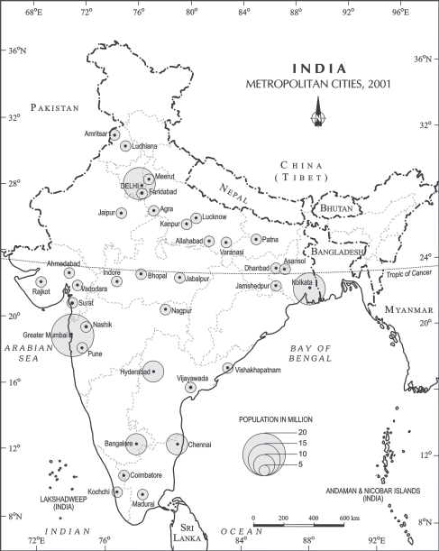
- Metropolitan Cities: 2-5 million population. However, according to the 74th Amendment, an area with a population of more than 2 Million is classified as a metropolitan area.
- Megacities: Cities with a population of more than 5 Million.
About 60% of the Urban population lives in Class I towns (>1 Lakh population). Out of 423 cities, 35 are urban settlements are Metropolitan; [Now 53 Million+ cities – 2011]
Urban Agglomerations
The majority of Mega Cities and Metropolitan are Urban agglomerations. Agglomerations have these combinations:
- town and its adjoining urban outgrowths,
- two or more contiguous towns with or without their outgrowths, and
- a city and one or more adjoining towns with their outgrowths together forming a contiguous spread.
Statutory Towns:
Those urban areas are declared a municipality, corporation, cantonment board, or notified town area committee by the State Government.
Thus, those towns which have been declared as urban settlements by the government authorities are statutory towns.
Census Towns:
Census towns are those areas that have enough population (as per the Census data) and largely host economic activities of an urban nature but are not statutory towns. In order to qualify as an urban area, these towns must satisfy the following criteria as per the definition given by the Registrar General of India:
- Population>5000
- Population density of at least 400 people/sq.km.
- At least 75% of the male population is employed outside the agricultural sector.

According to the Census data, we can have the following types of towns:
| Class I cities | Population> 1L | 465 |
| Metropolitan (out of above) | Population > 10L | 53 |
| All class | 7953 | |
| Statutory towns | Defined by the state government | 4041 |
| Census towns | Urban in nature | 3894 |
Functional Classification of Towns:
- Administrative towns: Chandigarh, ND, Bhopal, Shillong, Guwahati, Imphal, Srinagar, Gandhinagar, Jaipur, Chennai etc.
- Industrial towns: Mumbai, Salem, Coimbatore, Modinagar, Jamshedpur, Hugli, Bhilai etc.
- Transport cities:
- Port cities: Kandla, Kochi, Kozhikode, Vishakhapatnam etc
- Hubs of Inland transport: Agra, Dhulia, Mughal Sarai, Itarsi, Katni etc.
- Commercial towns: Specialising in trade and commerce: Kolkata, Saharanpur, Satna etc.
- Mining Towns: Mineral-rich areas: Raniganj, Jharia, Digboi, Ankaleshwar, Singrauli, etc.
- Garrison Cantonment towns: Ambala, Jalandhar, Mhow, Babina, Udhampur etc.
- Educational towns: Roorki, Varanasi, Aligarh, Pilani, Allahabad etc.
- Religious towns: Varanasi, Mathura, Amritsar, Madurai, Puri, Ajmer, Pushkar, Tirupati, Kurukshetra, Haridwar, Ujjain.
- Tourist towns: Nainital, Mussoorie, Shimla, Pachmarhi, JodHimachal Pradeshur, Jaisalmer, Udagamandalam (Ooty), and Mount Abu are some of the tourist destinations.

Mumbai with a population of 18 million and Delhi with a population of 16 million are the fastest-growing urban settlements.
Challenges to Urbanisation
- Poor access to basic services: access to clean water, sanitation and health care facilities.
- Pollution: Due to improper solid and liquid waste management, as well as vehicular and industrial emissions.
- Frequent Urban Flooding: due to poor drainage and encroached wetlands. With the increasing risk of Climate Change, the frequency of urban flooding is bound to rise.
- Urban Heat Island: Due to higher emissions and the nature of the surface, urban areas are increasingly experiencing severe heat waves each year.
- Disappearing Natural landscape: In cities like Delhi, Hyderabad, Bengaluru, Chennai etc. thousands of ponds and lakes have been encroached, along with forest areas and open green patches. In tier 2 and 3 towns too, a similar trend is seen.
- Congestion of traffic: Often due to poor road infrastructure and lack of enough public transport.
- Increasing Slum Population: According to the 2001 census, 4.3Cr people (24% of the urban population) live in urban slums. The majority are in Maharashtra (1.12 Cr) since Mumbai is home to the Dharavi slum, the World’s largest slum. While the slum population has increased, the number of slums has decreased – resulting in greater density.
- Poverty has urbanised. Urban poverty in India is over 25%; Around 8.1Cr of the urban population is Below the Poverty Line (BPL). The gap between urban ran rural poverty is quickly closing.
- Poor economic opportunities in tier II and tier III cities force the population to shift towards tier I cities.
Solutions:
- Counter-magnet cities: We need to create a counter-magnet area around the large mega-cities with enough economic opportunities.
- Afforestation and development of green areas: increasing the forest area is necessary to reduce greenhouse gases and decrease absorption in the urban centres.
- Improving Public transport: The government should incentivize public transport by investing and subsidizing it.
- Rurban concept: The process of performing agriculture and urban forestry in the open spaces in the urban areas.
- Promoting Green Transport: Further, the cities must be pedestrian friendly and there should be separate lanes for cycling and providing subsidies for Green fuel.
- Re-Planning Drainage system: which is easier to clean and de-silt, recognizes the importance of natural wetlands and artificial lakes; It should work on the principle of water security.
- The idea of a sponge city: making cities more permeable to absorb the rainwater, which is then naturally filtered by the soil and allowed to reach urban aquifers.
- Redevelopment of Slums.
We shall cover the concept of Urbanisation in detail in the Society book.


