Road & Highway Infrastructure- Notes for UPSC
Road and Highway Infrastructure
Roadways are the most important mode of transport known to humans. Roads carry 64.5% of total goods and 90% of the passenger traffic in India. Out of all the roads in India, National highways hold around 2% of the total road network and carry 40% of total traffic.
Acknowledging its importance, Highway construction has happened at a pace of 17.00% CAGR between FY16-FY21.

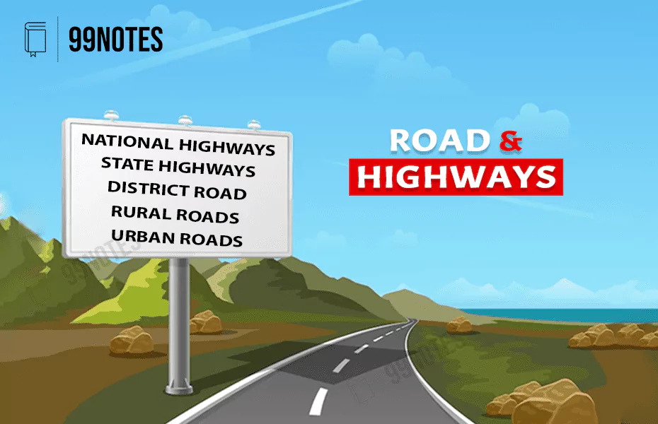
Categories of Roads in India:
| Category | Managing Authority |
| I. National highways (12m wide) | Ministry of Road Transport and Highways (MoRTH) |
| II. State highways (12m wide) | Public works department (PWD) of State Government/Union Territory |
| IIIA. Major District Road (9m)
IIIB. Other District Road (9-7.5m) |
|
| IV. Rural roads (<7.5m) | Panchayats and PM Gram Sadak Yojana |
| V. Urban roads | Municipal corporations and municipalities |
- Expressways are the roads having four or more high-speed lanes.
- Apart from these there are certain Project roads which are undertaken by various government departments of states/union territories, and SAIL, NMDCand
Development of Roads before 2000
- Before Independence, Jayakar Committee (1929) was formed which recommended that:
-
- Central Road Fund should be formed which can be funded by tax collected on Petrol. Its proceeds were to be used for road development work.
- A Central Road Research Institute (CRRI) was recommended. It was formed in 1950.
- For the expansion of Roadways, India had introduced twenty-year road plans since independence. Three such plans were introduced till 2000:
-
- Nagpur Road Plan (1943-63)
- Bombay Road Plan (1961-81)
- Lucknow Road Plan (1981-2001)
- These plans recommended targets for road density in plains and hilly areas.
- However, in 1998, Vajpayee government discontinued these plans and instead focused on a network of National Highways.
National Highways Authority of India (NHAI)• It is an autonomous body within the Ministry of Road Transport and Highways in 1988. • It is a statutory body created by promulgating the National Highways Authority of India Act 1988. • It is responsible for developing, maintaining, managing and operating 70,000 km of National Highways.
|
Government push towards Road Infrastructure
1. National Highway Development Project (NHDP), 1998:
- It was launched by PM Atal Vihari Vajpayee to improve the conditions of existing major highways of India.
- The program expanded into various phases:
- Phase I: Golden Quadrilateral: It connects the four metros by Express Ways, which falls under NHDP & managed by NHAI.
- Phase II: North–South & East–West 13,000Km of roads were constructed during the Phase I and Phase II of NHDP.
- Phase III, IV & V: focused on converting select Two-lane highways to Four-lane; and 4-lane to 6-lane.
- Phase VI & VII: focused more on Expressways (i.e. highways with more than 4 lanes). Chennai-Bangaluru & Kolkata-Dhanbad expressways were planned in Phase VI of NHDP.
2. Pradhan Mantri Gram Sadak Yojana (PMGSY):
- PMGSY aims to provide all-weather road connectivity to all competent unconnected habitations in rural areas of the country.
Habitations covered:
- Plain areas: a population of 500 persons and above (as per the 2001 Census),
- Special Category States and in Select Tribal and Backward Districts,
- Most intensive Integrated Action Plan (IAP) blocks identified by MHA .these are the unconnected habitations with a population of 100 and above[mainly LWE areas].
Funding for Pradhan Mantri Gram Sadak Yojana (PMGSY):
-
-
- 11 Special Category states = 90:10.
- Rest all 60:40 between centre state.
-
“Road Connectivity Project for Left Wing Extremism (LWE) Affected Areas” is a sub-scheme of PMGSY which is being implemented in 44 worst affected LWE and adjoining districts, critical from security and communication points of view.
3. Economic Corridors:
- The government of India plans to develop 44 highways (27,000 km) as “economic corridors” for the seamless movement of cargo, cut delays, deepen economic activities and create jobs.
- 40 interconnecting corridors will also be developed to link 44 economic corridors and the Golden Quadrilateral. This network will carry 80% of the country’s freight.
- The government will also rebrand national highways for better identification & Navigation of roads (using satellite imagery):
- National corridors
- Economic corridors
- Feeder roads
- As per Budget 2021, Some of the proposed Flagship Corridors:
- Delhi-Mumbai Expressway.
- Bengaluru-Chennai Expressway.
- Kanpur-Lucknow Expressway.
- Delhi-Dehradun economic corridor.
- Raipur-Vishakhapatnam corridor.
- Chennai-Salem corridor.
- Amritsar-Jamnagar corridor.
- Delhi-Katra corridor.
- Economic corridors can sometimes also be referred to as the Industrial corridor. For example, Bengaluru-Mumbai “Economic Corridor” is one of five Industrial corridors being developed in India. However, still some differences can be spotted:
| Economic Corridor | Industrial Corridor |
| 1. An Economic corridor is an integrated network of infrastructure to stimulate economic development in a specified geographical area.
2. Although it includes the development of Roads, Railways, Gas pipelines and Ports simultaneously working together. But it is associated more with highways. 3. e.g. Delhi-Dehradun economic corridor. |
1. It comprising multi-modal transport services which would pass through the various states as the main artery.
2. It is a single network system which aims to lower the costs of logistics and enhance supply chain management. 3. e.g. Delhi Mumbai Industrial corridor. |
4. Setu Bharatam Programme, 2016:
- It is to make all national highways free of railway-level crossings by 2019, to prevent frequent accidents at level crossings.
5. Bharatmala Project:
- It is the country’s 2nd largest highway construction project under NHDP, which the Union Cabinet cleared on October 25, 2017.
- Objective: The main objective is to build 66,100 km of economic corridors, border and coastal roads, backward areas, religious & tourist places and expressways to boost the highway network.
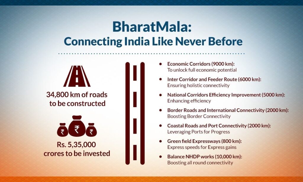
Source: https://blog.mygov.in/editorial/bharatmala-connecting-india-like-never-before/
6. Char-Dham Mahamarg:
- It connects Kedarnath, Badrinath, Yamunotri and Gangotri in Uttarakhand.
- Features:
-
- All-in-Star connections Via
- It will Complement Char-Dham Railway.

- Silkyara Bend-Barkot Tunnel will provide all-weather connectivity to Yamunotri, reducing the distance from Dharasu to Yamunotri.
Other initiatives:
1. The rationalised numbering:
The new rationalised numbering of National Highways was introduced in 2010 by the government of India. Some of them are:
- Odd: All East-West highways increasing from the north towards the South.
- Even: All North-South highways increasing from the east towards the West.
- Major highways have single or double–digit
- Suffixes A, B, C, D, are added to the three-digit sub-highways to indicate very small spin-offs or stretches of sub-highways.

LIST: https://en.wikipedia.org/wiki/List_of_National_Highways_in_India_by_highway_number
2. Indian Bridge Management System (IBMS):
This will generate a catalogue of all bridges nation-wise and rate their structural condition for timely repair. 5 numbers have been assigned in this regard:
- UID or National Identity Number assigned to each bridge based on the state, RTO zone and whether it is situated on a National Highway, State Highway or district road.
- Geo-Tagging: Every bridge will be assigned a unique Location Number.
- Engineering characteristics: Design, materials, type of bridge, its age, loading, traffic lane, length, the width of carriageway etc., used to assign a Bridge Classification Number.
- Structural rating Number: on a scale of 0 to 9. The rating is done for each of its components.
- Socio-Economic Bridge Rating Number: contribution to the everyday socio-economic activity of the fields in its vicinity.
3. Green Highway policy, 2015:
- It aims to promote greening of Highways. For this the government takes several policy initiatives.
- Green Highway Fund: Every year, 1% of the civil work cost of highway projects will go to the Green Highways Fund, which is about ₹1000Cr/year. This will be included in the Total work cost & will be available for plantation purposes.
- Objectives:
-
- Achieving Forest cover: 33% by developing a policy framework for tree plantation along highways.
- Safe road: due to shade from sunlight & preventing the glare from the headlights of oncoming vehicles.
- Air Pollution: Reducing the impact of air pollution/dust and noise pollution.
- Easy ride: Providing shade on glaring hot roads during summer.
- Generating employment: opportunities for about five lakh people from rural areas.
- Monitoring mechanism: With the help of ISRO’s Bhuvan & GAGAN satellite, every planted tree will be counted, and auditing will be done.
4. FASTags:
The authority ensured the mandatory Implementation of FASTags from December 01 2019, on all NHAI toll plazas. It is also known as ‘Aadhar for Vehicles’.
- It is a prepaid Radio frequency Identification enabled tag. Motorists must maintain a speed of 20-25kmph when approaching the boom, and the toll charge will automatically be deducted.
- Advantage:
- Saves time, fuel and use of paper: A joint study in 2014-15 by the Transport Corporation of India and IIM Calcutta estimated the cost of delay on roads: at $6.6bn/year & cost of fuel consumption at $14.7bn. Fastag would save all this time and cost.
- Provides authentic data to the government for better analysis & policy formation
- Implementation: By Indian Highway management company limited (IHMCL) incorporated by NHAI.
5. Meghalaya Integrated Transport Project (MITP), 2020:
The Government of India, the Govt of Meghalaya and the World Bank have signed this $120 million project to enhance and modernise the transport sector of Meghalaya.
Road Safety
The National Crimes Records Bureau (NCRB) releases a report on Accidental Deaths in India. The national Road Safety Council (NRSC) is the apex for making policy decisions.
1. Status:
Traffic Crash Injuries and Disabilities: The Burden on Indian Society – A world bank report:
- India has the world’s worst record on road safety.
- 53 road crashes, 17 deaths per hour in 2018.
- 2020: total 1.2L accidents – NCRB.
- Indian population has 1% of the world’s vehicles but faces 11% of all road accident deaths.
- UP, Bihar, Tamil Nadu and Maharashtra – that account for 35% of road accident deaths to find the link between road crash fatalities and inequality, poverty, and vulnerable road users in India.
2. The consequence of Road accidents:
- Death: As per 2019 data India’s highways witnessed 61% of deaths from 5% of all accidents.
- Reduced Income: More than 75% of poor households reported a decline in their income due to a road crash death.
- Poverty: pushes the kin of victims into a cycle of poverty and debt in India. Around 64% of low-income households reported a deterioration in their standard of living.
- Impacts more on the poorer household: Those who suffer the most are from low-income rural households.
- Mental Trauma: More than 50% reported mental depression post-crash.
- Impact on women: About 50% of women were severely affected by the decline in household income after a crash. About 40% of women reported a change in their working patterns post-crash, while around 11% reported taking up extra work to deal with the financial crisis.
3. Challenges:
- The problem of Populism: Most States have been unenthusiastic towards hard steps to bring order to the roads, viewing zero-tolerance rule enforcement through the lens of populism.
- Inadequate investment in road safety.
- Awareness Creation: Nearly 3% of GDP loss can be saved by spreading safety awareness.
- Loose Implementation of road safety rules.
4. Steps taken:
- Government Aim: To reduce road crash deaths by 50% by 2024, in line with the Brasilia declaration (which aims to reduce road accidents by 50% reduction by 2022).
- Policy level changes:
- National Road Safety Policy should be implemented on a priority basis.
- Motor Vehicle (Amendment) Act, 2019.
- India’s Road Safety Month launched on January 2021 to create awareness.
- Setu Bharatam Programme, 2016 made all national highways free of railway level crossings by 2019.
- Indian Bridge Management System (IBMS) was established to complete conditions survey and incentivise all bridges on national highways using mobile inspection units.
- National Highway Accident Relief Service Scheme(NHARSS) came into the picture to provide cranes and ambulances to states/UTs/NGOs for relief and rescue measures in the aftermath of accidents for swift evacuation.
- As per Green Highway policy, in 2015, 1% of the civil work cost of highway projects will go Green highway Fund which is about ₹1000Cr/year, which will be available for plantation purposes along the highways. This would prevent glare and heat and reduce the number of accidents.
- New pedestrian safety regulations align with the UN standards for front and side impact and pedestrian protection.
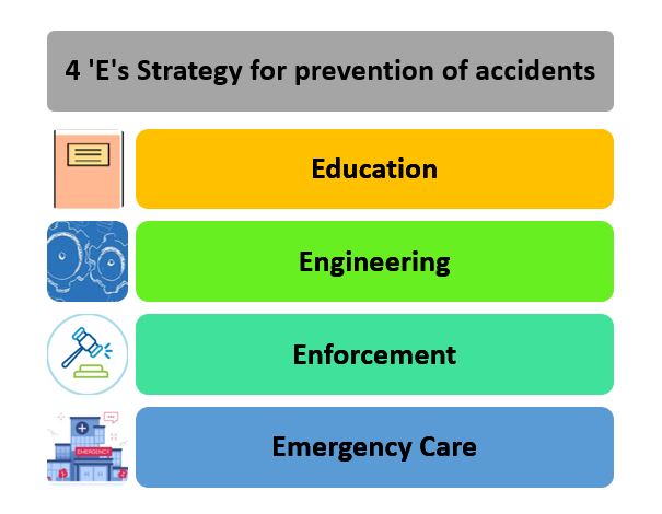
Ending the “silent pandemic” of accidents will need education, civil society cooperation and professional policing. Meeting the SDGs on transport and reducing road deaths and injuries will require actions beyond pious declarations.
The Centre must now set a timeline to operationalise the National Road Safety Board, for which draft rules to lay down engineering standards and complaints procedures that will help citizens hold States to account.



![What Is Social Infrastructure: Meaning, Importance &Amp; Challenges [Upsc Notes] | Updated February 19, 2026 What Is Social Infrastructure: Meaning, Importance & Challenges [Upsc Notes]](https://99notes.in/wp-content/uploads/2023/05/social-infrastructure-99notes-upsc-1-768x512.webp)
